- Camp Cooking Supplies
- Camp Furniture
- Camping & Hiking Hydration
- Camping Beds & Sleeping
- Camping Equipment
- Camping Heating & Cooling
- Camping Lighting
- Camping Power & Solar
- Camping Toilets & Showers
- Electronics
- Gazebos – Awnings & Shades
- Health & Safety
- Packs & Bags
- Portable Fridges & Coolers
- Tents
- Pet Supplies
-80%


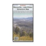
Rooftop Marysville – Lake Eildon Map
Original price was: AUD$17.50.AUD$3.50Current price is: AUD$3.50.
Hurry up! Sale Ends in
Only 12 left in stock
84 people are viewing this right now
G****e purchased in Chicago,  United States bought this(10 Minutes ago)
United States bought this(10 Minutes ago)
Over 60 people have this in their carts right now
Description
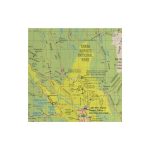
A double-sided map includes Lake Eildon & Yarra Ranges National Parks, Mansfield, Woods Point, Lake Mountain, Jamieson and more. Also features pictures of Murrindindi and Mansfield and individual town maps of Mansfield, Eildon, Alexandra, Marysville and Woods Point as well as Lake Mountain and Cathedral Ranges.
Map coverage is from Mansfield, Bonnie Doon and Merton in the north to Warburton Upper Yarra reservoir and Matlock in the south. It includes Marysville, Lake Mountain, Cathedral Range, Yarra Ranges National Park, Big River, Rubicon, Eildon, Gaffneys Creek, Woods Point and Jamieson. Scale is 1:100,000.
The reverse of the map has enlargements of the Cathedral Range, Marysville Walks, Buxton Mountain bike trails, Marysville rebuild (a fascinating map), and a pictorial guide to what’s under Lake Eildon.
All parks, reserves and state forests are shown and all roads and tracks have been plotted using GPS mapping technology.
- Model / Product Code
- 9781921886126
- Material
- Paper
- Product Weight
- 7 g
- Warranty
- 12 months
- Primary Activity(s)
- 4WD & Offroad
- EAN
9781921886126
Reviews (0)
Reviews
There are no reviews yet.