- Camp Cooking Supplies
- Camp Furniture
- Camping & Hiking Hydration
- Camping Beds & Sleeping
- Camping Equipment
- Camping Heating & Cooling
- Camping Lighting
- Camping Power & Solar
- Camping Toilets & Showers
- Electronics
- Gazebos – Awnings & Shades
- Health & Safety
- Packs & Bags
- Portable Fridges & Coolers
- Tents
- Pet Supplies
-80%


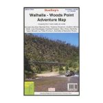
Rooftop Walhalla – Woods Point Map
Original price was: AUD$17.50.AUD$3.50Current price is: AUD$3.50.
Hurry up! Sale Ends in
Only 12 left in stock
84 people are viewing this right now
G****e purchased in Chicago,  United States bought this(10 Minutes ago)
United States bought this(10 Minutes ago)
Over 60 people have this in their carts right now
Description
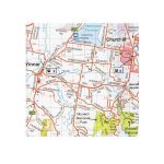
A double-sided map that covers from Tarra Valley to Licola, including Baw Baw National Park, Thomson Reservoir, Heyfield, Mirboo North, Lake Glenmaggie, Traralgon, Moe, Erica, and Aberfeldy, as well the Tyers, Morwell, La Trobe, Thomson, Aberfeldy and Macalister Rivers. The reverse side covers from Walhalla to Woods Point, complete with forest activity information.
Coverage includes Walhalla, Woods Point, Baw Baw National Park, Thomson Reservoir, Heyfield, Mirboo North, Lake Glenmaggie, Traralgon, Moe, Erica, Aberfeldy, Tyers, Morwell, Blackwarry, Tarra-Bulga National Park and Won Wron.
Roads and tracks have been carefully plotted using a GPS and all important recreational and land features have been included.
Ideal map for following the Aberfeldy Tracks between Walhalla and Woods Point.
The main map is at 1:100,000 scale. On the reverse side is the Walhalla – Woods Point Forest Activities Map at 1:50,000 scale with contours.
- Model / Product Code
- 9781921886102
- Material
- Paper
- Product Weight
- 9 g
- Warranty
- 12 months
- Primary Activity(s)
- 4WD & Offroad
- EAN
9781921886102
Reviews (0)


Reviews
There are no reviews yet.