- Camp Cooking Supplies
- Camp Furniture
- Camping & Hiking Hydration
- Camping Beds & Sleeping
- Camping Equipment
- Camping Heating & Cooling
- Camping Lighting
- Camping Power & Solar
- Camping Toilets & Showers
- Electronics
- Gazebos – Awnings & Shades
- Health & Safety
- Packs & Bags
- Portable Fridges & Coolers
- Tents
- Pet Supplies
-80%


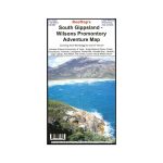
Rooftop South Gippsland – Wilsons Promontory Map
Original price was: AUD$17.50.AUD$3.50Current price is: AUD$3.50.
Hurry up! Sale Ends in
Only 12 left in stock
84 people are viewing this right now
G****e purchased in Chicago,  United States bought this(10 Minutes ago)
United States bought this(10 Minutes ago)
Over 60 people have this in their carts right now
Description
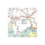
South Gippsland – Wilsons Promontory Map
Map coverage includes Wilsons Promontory and Tarra – Bulga National Parks, Foster, Korumburra, Inverloch, Leongatha, Walkerville, Waratah Bay, Yanakie, Cape Liptrap, Port Albert, Fish Creek, Corner Inlet, Mirboo North, Yarram, Woodside and Wonthaggi. Scale is 1:100,000.
The reverse of the map has a 1:50,000 scale enlargement titled ‘Wilsons Promontory Forest Activities Map’ with contours.
All parks, reserves and state forests are shown and all roads and tracks within the map area have been plotted using GPS mapping technology. All walking tracks in Wilsons Promontory National Park have been recently field checked with detailed plots showing camp sites, navigational notes and important features.
- Model / Product Code
- 689076913560
- Material
- Paper
- Product Weight
- 9 g
- Warranty
- 12 months
- Primary Activity(s)
- 4WD & Offroad
- EAN
689076913560
Reviews (0)


Reviews
There are no reviews yet.