- Camp Cooking Supplies
- Camp Furniture
- Camping & Hiking Hydration
- Camping Beds & Sleeping
- Camping Equipment
- Camping Heating & Cooling
- Camping Lighting
- Camping Power & Solar
- Camping Toilets & Showers
- Electronics
- Gazebos – Awnings & Shades
- Health & Safety
- Packs & Bags
- Portable Fridges & Coolers
- Tents
- Pet Supplies
-80%


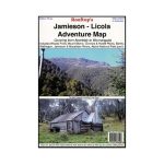
Rooftop Jamieson – Licola Map
Original price was: AUD$17.50.AUD$3.50Current price is: AUD$3.50.
Hurry up! Sale Ends in
Only 12 left in stock
84 people are viewing this right now
G****e purchased in Chicago,  United States bought this(10 Minutes ago)
United States bought this(10 Minutes ago)
Over 60 people have this in their carts right now
Description
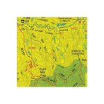
A map that covers from Aberfeldy to Wonnangatta, including Woods Point, Mount Skene, Alpine National Park, Wellington, Jamieson, Macalister and Thomson Rivers, Connors and Howitt Plains.
Map coverage is from Goughs Bay, Jamieson and the Howqua River in the north to the Upper Thomson, Aberfeldy and Licola in the south.
It includes Woods Point, Mount Skene, Alpine National Park, Wellington, Jamieson, Macalister and Thomson Rivers, Connors and Howitt Plains. Scale is 1:100,000.
The reverse of the map has a 1:50,000 scale enlargement titled ‘Sheepyard Flat – Caledonia Valley Forest Activities Map’ with contours.
Excellent map for all users whether it is 4WD, dirt bike riding or walking that you are interested in.
All parks, reserves and state forests are shown and all roads and tracks have been plotted using GPS mapping technology.
- Model / Product Code
- 9781921886096
- Material
- Paper
- Product Weight
- 6 g
- Warranty
- 12 months
- Primary Activity(s)
- 4WD & Offroad
- EAN
9781921886096
Reviews (0)


Reviews
There are no reviews yet.