- Camp Cooking Supplies
- Camp Furniture
- Camping & Hiking Hydration
- Camping Beds & Sleeping
- Camping Equipment
- Camping Heating & Cooling
- Camping Lighting
- Camping Power & Solar
- Camping Toilets & Showers
- Electronics
- Gazebos – Awnings & Shades
- Health & Safety
- Packs & Bags
- Portable Fridges & Coolers
- Tents
- Pet Supplies
-80%


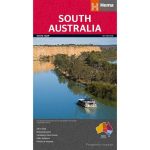
Hema South Australia State Map Multicoloured
Original price was: AUD$17.50.AUD$3.50Current price is: AUD$3.50.
Hurry up! Sale Ends in
Only 12 left in stock
84 people are viewing this right now
G****e purchased in Chicago,  United States bought this(10 Minutes ago)
United States bought this(10 Minutes ago)
Over 60 people have this in their carts right now
Description
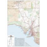
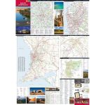
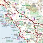
A map of South Australia (SA) for touring throughout the state that has camping and rest areas, 24-hour fuel and points of interest marked on the mapping. On the reverse are CBD, surrounding region and through road maps of Adelaide in addition to maps of Flinders Ranges National Park and the Barossa Valley. Also included are listed national parks and information centres within South Australia.
- Features
- Full map of South Australia
Major road networks and distances marked
Includes CBD inset of Adelaide in addition to maps of Flinders Ranges National Park and Barossa Valley
Camping, rest areas and visitor information centres featured
- Material
- Paper
- Dimensions
- 100 x 70 cm
- Packed Dimensions
- 25 x 14 cm
- Contents
- 1 folded map
- Primary Activity(s)
- Travel
Caravanning - EAN
9781865009865
Reviews (0)
Reviews
There are no reviews yet.