- Camp Cooking Supplies
- Camp Furniture
- Camping & Hiking Hydration
- Camping Beds & Sleeping
- Camping Equipment
- Camping Heating & Cooling
- Camping Lighting
- Camping Power & Solar
- Camping Toilets & Showers
- Electronics
- Gazebos – Awnings & Shades
- Health & Safety
- Packs & Bags
- Portable Fridges & Coolers
- Tents
- Pet Supplies
-80%


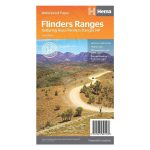
Hema Flinders Ranges Map Multicoloured
Original price was: AUD$17.50.AUD$3.50Current price is: AUD$3.50.
Hurry up! Sale Ends in
Only 12 left in stock
84 people are viewing this right now
G****e purchased in Chicago,  United States bought this(10 Minutes ago)
United States bought this(10 Minutes ago)
Over 60 people have this in their carts right now
Description
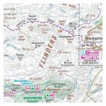
A waterproof map of the Flinders Ranges with inset national park maps of Flinders Ranges National Park and Vulkathunha-Gammon Ranges National Park. Visitor information for both the national parks, the Leigh Creek region and the Blinman region make trip planning and navigation simple, with accompanying tourist information including self-drive treks, historic sites, necessary contact details and listed national parks and reserves. Marked on the maps are camping areas, points of interest and more.
- Features
- Printed on waterproof and tearproof paper
Features information on major 4WD tracks
Major tourist attractions and road distances marked
National parks marked including contact information and events
Camping areas and points of interest included throughout
GPS surveyed roads and tracks
- Primary Activity(s)
- Travel
4WD & Offroad
Caravanning - EAN
9321438001607, 9781865007151, 9781925625578
Reviews (0)


Reviews
There are no reviews yet.