- Camp Cooking Supplies
- Camp Furniture
- Camping & Hiking Hydration
- Camping Beds & Sleeping
- Camping Equipment
- Camping Heating & Cooling
- Camping Lighting
- Camping Power & Solar
- Camping Toilets & Showers
- Electronics
- Gazebos – Awnings & Shades
- Health & Safety
- Packs & Bags
- Portable Fridges & Coolers
- Tents
- Pet Supplies
-80%


Hema Central Australia Map Multicoloured
Original price was: AUD$17.50.AUD$3.50Current price is: AUD$3.50.
Hurry up! Sale Ends in
Only 12 left in stock
84 people are viewing this right now
G****e purchased in Chicago,  United States bought this(10 Minutes ago)
United States bought this(10 Minutes ago)
Over 60 people have this in their carts right now
Description
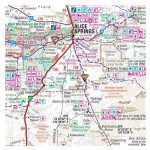
An off-road regional map of central Australia that covers between Woomera in the south to Tennant Creek in the north, then from Windorah in the east past Yulara to the Warakurna Roadhouse in the west. On the opposite side are travel tips, photos, map coordinates and background information on outback regions including the Red Centre, East & West MacDonnell Ranges, Finke River region, around the Old Ghan, the Simpson Desert, Flinders Ranges, Corner Country, Channel Country, and Mt Isa to Tennant Creek. Central Australia’s Great Trips are outlined also, with the Strzelecki Track, along the Stuart, Birdsville Track, Oodnadatta Track, Tanami Road, Sandover Highway and Plenty Highway featured. Included in each track’s description is the length, longest time without fuel, facilities and a drive description.
- Features
- Features information on major touring routes
Major tourist attractions and road distances marked
National parks marked including contact information and events
Camping areas and points of interest included throughout
Highlights Great Central Australia off-road trips
GPS surveyed roads and tracks
- Packed Dimensions
- 210 x 100 mm
- Primary Activity(s)
- Travel
4WD & Offroad
Caravanning - EAN
9781925625738, 9781865006734
Reviews (0)


Reviews
There are no reviews yet.